Fatal Accident (2) – Mooney M20R Ovation 2 GX, N595RJ, Velika Planina, Slovenia, March 10, 2025

ASX Investigation | ||||
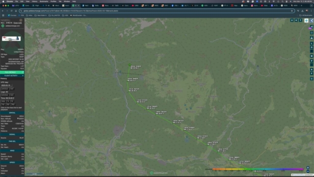
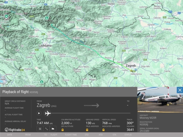
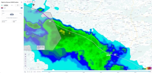
On the morning of March 10, 2025, a privately operated Mooney M20R Ovation 2 GX aircraft, registered as N595RJ, departed from Zagreb-Pleso Airport (LDZA) en route to Birrfeld Airfield (LSZF) in Switzerland. The aircraft, manufactured in 2005 and bearing MSN 29-0389, was flown by a sole pilot and was engaged in a private flight. The aircraft was equipped with ADS-B, which provided real-time tracking until the final moments of flight. Contact with the aircraft was lost while it was traversing Slovenian airspace, specifically near the mountainous region of Velika Planina. The final ADS-B data indicated the aircraft was cruising at approximately 9,675 feet pressure altitude before initiating a descending right-hand turn. The descent intensified rapidly into what has been identified as a spiral dive, with a final recorded descent rate averaging approximately -17,250 feet per minute. The aircraft subsequently disappeared from radar coverage near Velika Planina, at which point Slovenian air traffic control lost communication with the pilot. The aircraft’s last known coordinates correspond with mountainous terrain, making terrain impact likely. Shortly after the loss of radar contact, a large-scale search and rescue operation was initiated by Slovenian authorities, including police units, fire brigades, mountain rescue teams, and air support. At approximately 12:30 local time, search teams discovered aircraft debris near a structure associated with the Faculty of Mechanical Engineering, which appeared to have been impacted by the aircraft. Wreckage included sections of the wing and landing gear components. The main fuselage and cockpit remained unlocated at the time, prompting continued search efforts throughout the day and into the following night. Meteorological data from Ljubljana Airport (LJLJ), located approximately 25 km from the crash site, reported poor visibility and low ceilings around the time of the incident. Weather conditions included broken clouds at 2,000 feet AGL, overcast layers at 3,200 feet AGL, light rain, and surface visibility of approximately 4.5 miles. Local terrain elevations, combined with low ceilings and precipitation, contributed to reduced visual flight conditions. Reports also indicated that rescue helicopters faced difficulty navigating the area due to these same conditions. The degraded meteorological conditions, particularly the low cloud ceiling and visibility limitations, are strongly correlated with the pilot’s likely loss of situational awareness and spatial orientation. The descent pattern captured by ADS-B suggests an uncontrolled descent rather than a standard approach profile, consistent with disorientation or attempted avoidance maneuvers in terrain-imposed instrument meteorological conditions (IMC). There is no current indication of mechanical failure, and the event is under investigation by the appropriate accident investigation authority. At the time of reporting, the pilot is confirmed deceased, and the aircraft is considered destroyed. The flight was categorized as a non-commercial, private operation with only the pilot onboard. The investigation continues under the supervision of national authorities, with ongoing efforts to recover the remaining wreckage and evaluate potential contributing factors, including human performance, operational decision-making, and the influence of atmospheric conditions. | ||||
Accident Information | ||||
Approx. Accident Location | Aircraft Fatalities 1 | Ground Fatalities 0 | Injured 0 | |
Aircraft Information | ||||
Aircraft Type | Operator Private | Registration | Serial Number | Manufacture date |
Relevent Flight Tracking | ||||
Relevent Social Media | ||||
References | ||||
Local News | World News | Image References | ||
Miscellaneous | ||||
Accident Weather | Additional | Official Preliminary Report | Official Final Report | |

